Hoi An or Da Nang: where to base yourself
Hoi An or Da Nang? What each base offers, the bus between them, airport access, the beaches, and the rain and flood months in central Vietnam.

On this page
At a glance
| Where | Hoi An and Da Nang, on the coast of central Vietnam. Both have been part of Da Nang city since 1 July 2025.As of 2026-10-20 · Source: Resolution No. 202/2025/QH15; Resolution No. 1659/NQ-UBTVQH15; Da Nang city tourism portal · Recheck by 2027-04-20 |
|---|---|
| Short answer | Hoi An for the old town, river evenings and the beaches at An Bang and Cua Dai. Da Nang for the airport, a long city beach, the Marble Mountains and Son Tra. |
| Between the two | Bus 02, Da Nang Central Bus Station to Cua Dai via Hoi An: 5.15am to 6.30pm, every 15 to 30 minutes. 8,000 VND up to 10 km, 20,000 VND to 25 km, 30,000 VND beyond.As of 2026-10-20 · Source: DanaBus (Da Nang Intelligent Traffic Control Centre) · Recheck by 2027-01-20 |
| Airport | About 3 km from Da Nang’s centre. T1 domestic, T2 international. Bus 06 from the airport, 5.45am to 7.25pm, every 30 to 60 minutes, 15,000 or 22,000 VND.As of 2026-10-20 · Source: Da Nang city tourism portal; DanaBus · Recheck by 2027-01-20 |
| Old town ticket | 80,000 or 120,000 VND, by the sites included. One ticket covers your stay, up to 3 days. Exempt: children under 16 years old, among others.As of 2026-10-20 · Source: Hoi An World Cultural Heritage Conservation Center · Recheck by 2027-01-20 |
| Rain, floods, storms | Da Nang: October is the wettest month, at 658 mm. The UK advice says seasonal flooding occurs in October and November in central Vietnam, and the cyclone season normally runs from May to November.As of 2026-10-20 · Source: VNMHA via WMO; UK FCDO · Recheck by 2027-04-20 |
| Entry and visa | Depends on your passport. Check the rule for your passport with your government’s travel advice and Vietnam’s immigration authorities before you book.As of 2026-10-20 · Source: UK FCDO entry requirements · Recheck by 2027-04-20 |
| Health | We give no health advice. For vaccines and health entry rules, see the official source.Source: UK FCDO, Vietnam health advice |
- Facts checked
- Next recheck
- Entry rule shown for
- None. For entry rules, check your own government’s travel advice.
The short answer
This guide is research, not a first-hand visit. We built it from the official sources listed at the end, as of the date in the ticket.
Base yourself in Hoi An if the old town is the reason for your trip. You step out into lantern-lit lanes in the evening.
Base yourself in Da Nang if you want the airport close and a long city beach. Hoi An then becomes a day or evening trip.
With four nights or more, split the stay. Start in Da Nang, near the airport, then move to Hoi An, with the Marble Mountains as a stop on the way.
| Hoi An | Da Nang | |
|---|---|---|
| Suits | Heritage, slow days, river evenings | Beach days, nightlife, day trips |
| Sea | An Bang and Cua Dai, outside the old town | My Khe and kilometres of city beach |
| Airport | A direct Hai Van Bus in the daytime, or a car | About 3 km from the centre |
| Day trips | My Son, the Cham Islands by boat | Son Tra, Ba Na Hills, the Hai Van Pass |
| Wet season | Rain and a few small floods from September to November, the tourism site says; cyclones | Floods across central Vietnam in October and November; cyclones |
Names on the map since 2025
On 12 June 2025, the National Assembly merged the former Da Nang city and Quang Nam province into a new city named Da Nang, with new local governments from 1 July 2025. A resolution of the National Assembly Standing Committee then set the wards. Minh An, Cam Pho, Son Phong and Cam Nam wards and Cam Kim commune became Hoi An ward, where the city tourism portal lists the Ancient Town. Cam Chau, Cua Dai and Cam Thanh became Hoi An Dong, and Thanh Ha, Tan An, Cam An and Cam Ha became Hoi An Tay.
A booking may now show “Hoi An Ward, Da Nang”, and an older map may still show the old ward names, such as Minh An.
Basing yourself in Hoi An
The Ancient Town
The national tourism site says Hoi An became a UNESCO World Heritage Site in 1999, and that its ancient core kept its original architecture and street plan. At its centre is the Japanese Covered Bridge, shown on the 20,000 VND note.
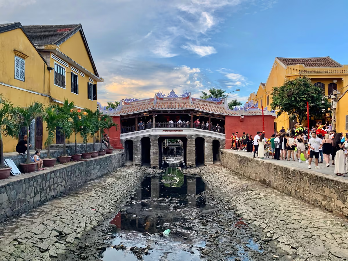
Fig. 1 The Japanese Covered Bridge, renovated in 2024. Photo: Chainwit. (opens in a new tab) · CC BY 4.0 (opens in a new tab) · modified
The reason to sleep here is the evening. The tourism site says the Old Town “comes to life at night, when the quarter glows with soft lantern light”, and that on the 14th day of each lunar month, people place candle-lit lanterns on the river. It describes days here as spent “at a slower pace”, with cooking classes, lantern-making workshops and basket-boat trips to Cam Thanh.
The ticket. The Hoi An World Cultural Heritage Conservation Center asks visitors to buy a ticket before they enter the ancient town. Its notice of 28 January 2026 lists two tickets:
- 80,000 VND: the town’s general landscape, the Japanese Covered Bridge or Quan Cong Temple, and two more sites of your choice.
- 120,000 VND: the town’s general landscape, the Japanese Covered Bridge or Quan Cong Temple, one site in the museum system and three more sites of your choice.
A ticket is “valid throughout the stay in Hoi An (up to 03 days)”. The centre exempts “children under 16 years old; people from poor households; journalists, researchers, and members of the Vietnam Heritage Association; people with severe disabilities as defined by the government”. The city tourism portal’s 2026 list, which it calls “for reference only”, labels 120,000 VND as the international price and gives different child rules: 50,000 VND for children 1 to 1.4 m, and free under 1 m.
Walking hours. The notice sets “Walking and Cycling town” hours in the ancient town: 9am to 9.30pm in summer and 9am to 9pm in winter. On Phan Chau Trinh Street, they start at 5.30pm. If you arrive by car with luggage, ask your stay where a car can stop.
The trade-off is water. The old town lies along the Thu Bon River. See the flood season section below.
An Bang beach
The tourism site calls An Bang “the most popular beach in Hoi An” and the most developed, with mostly single-storey cafes and restaurants and no skyscrapers on the horizon.

Fig. 2 An Bang beach, with a basket boat. Photo: Edgardo W. Olivera (opens in a new tab) · CC BY 2.0 (opens in a new tab) · modified
The site says visitors and locals arrive an hour or two before sunset to eat and drink. Stands at the main entrance rent out jet skis, paddleboards and surfboards. Stay near An Bang if you want the sea every day and the old town in the evening.
Cua Dai beach
The tourism site says Cua Dai was Hoi An’s most popular beach until the hospitality industry shifted to An Bang. It now calls Cua Dai “the place to go to escape crowds”, with restaurants and bars still close and fishing boats on the sand by day.

Fig. 3 Cua Dai beach, with sunshades. Photo: Edgardo W. Olivera (opens in a new tab) · CC BY 2.0 (opens in a new tab) · modified
Bus 02 ends at the Cua Dai wharf car park. The tourism site says speedboats leave daily from Cua Dai pier for the Cham Islands (Cu Lao Cham), in about 25 minutes. The same page says the islands are “virtually inaccessible during the monsoon season from October to February due to rough seas”, and that March to September brings calm waters.
Basing yourself in Da Nang
The city and the Han River
The national tourism site says Da Nang lies “a short drive away from Hoi An”. Its itinerary suggests a walk from the centre to the Museum of Cham Sculpture, which holds finds from the central coast and My Son, then a stroll on Bach Dang Street along the Han River.
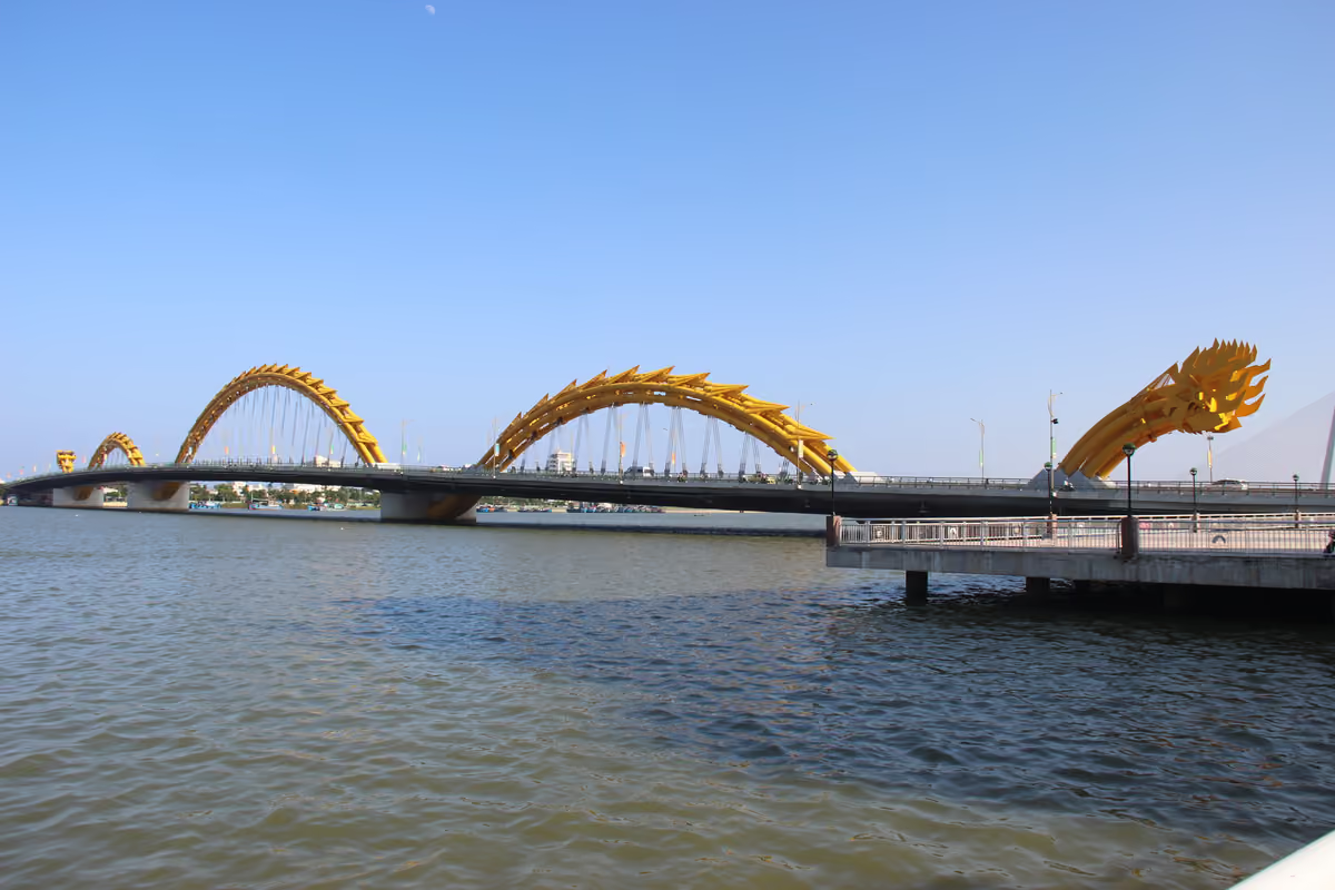
Fig. 4 The Dragon Bridge over the Han River. Photo: Gary Todd (opens in a new tab) · CC0 (opens in a new tab) · modified
Stay near the river for museums, cafes and restaurants on foot, with the beach a short ride away. The tourism site also mentions Da Nang’s “exciting nightlife”.
My Khe and the city beaches
The tourism site says Da Nang’s beach runs for kilometres from the Son Tra Peninsula towards Hoi An. It names Non Nuoc, Pham Van Dong, My Khe and My Anh as the main beaches at the southern end, and My Khe as the most popular, busy just before sunset, with seafood restaurants nearby.
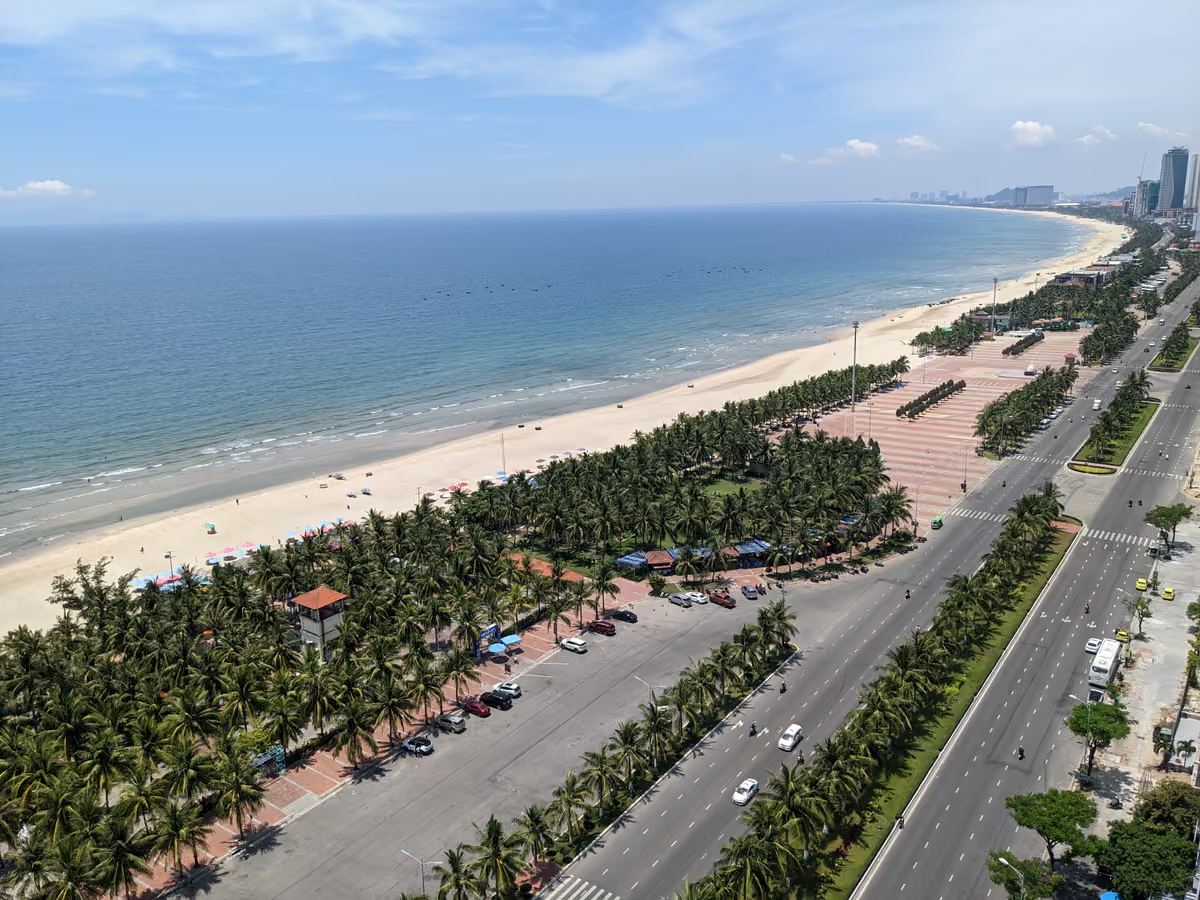
Fig. 5 My Khe beach and the seafront road. Photo: Jpatokal (opens in a new tab) · CC BY-SA 4.0 (opens in a new tab) · modified
The trade-off is scale. The tourism site contrasts An Bang with “the metropolis that characterizes Da Nang’s beaches”. For surfers, its itinerary says the shores “get some excellent surf between November and March”.
The Marble Mountains
The tourism site describes the Marble Mountains (Ngu Hanh Son) as five limestone peaks seven kilometres from downtown Da Nang, named after the five elements. They hold caves, tunnels, towers and pagodas, reached by stone steps or a lift.
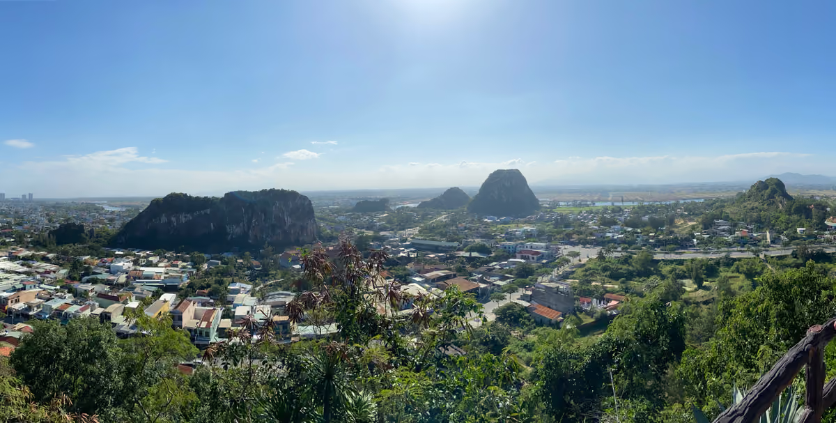
Fig. 6 The Marble Mountains seen from above. Photo: Kuroczynski (opens in a new tab) · CC BY-SA 4.0 (opens in a new tab) · modified
The site places them a short drive from the city, towards Hoi An, so they suit either base. It asks visitors to wear modest clothing at this pilgrimage site and to remove shoes and hats in the pagodas. It suggests at least two hours, away from the rainy season and the hottest hours of the day.
The Son Tra Peninsula
The tourism site describes Son Tra as a nature reserve about 10 km north-east of the city, with 4,000 hectares of rainforest. It names the Linh Ung Pagoda and its 67-metre white Lady Buddha statue, and says you may spot the endangered red-shanked douc on the way up.
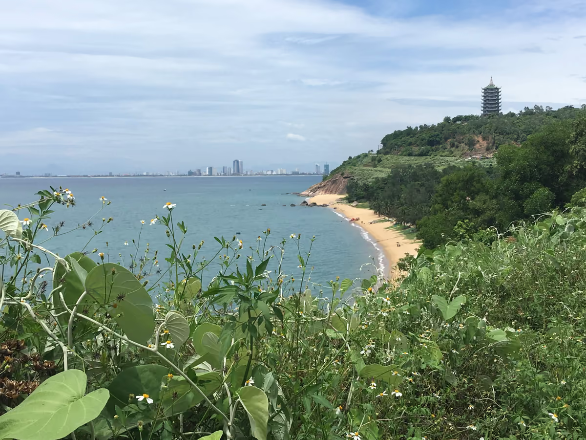
Fig. 7 Linh Ung Pagoda on Son Tra, with Da Nang beyond. Photo: Christophe95 (opens in a new tab) · CC BY-SA 4.0 (opens in a new tab) · modified
Its itinerary suggests a ride around the peninsula for views of My Khe to the south and the Hai Van Pass to the north.
Getting between Hoi An and Da Nang
The tourism site describes a “45-minute trip out to the Hoi An Ancient Town” from Da Nang. You can go by public bus, taxi or ride-hailing car.
Fig. 8 Bus 02, Da Nang to Hoi An Source: DanaBus, route 02 (opens in a new tab), October 2026.
The bus portal gives route 02 from 5.15am to 6.30pm, every 15 to 30 minutes. The single fare depends on distance: 8,000 VND up to 10 km, 20,000 VND up to 25 km, and 30,000 VND beyond. The diagram shows a few points from the route description; the full stop list is longer.
We give no taxi fare between the two, because we found no current official one. The UK advice says metered taxis from larger firms are generally reliable, and suggests that, where possible, you “get hotels or restaurants to book you a reputable taxi”. If you book through Grab, it says you can make sure the vehicle and driver match the details the company gives.
Arriving at Da Nang International Airport
The city tourism portal puts the airport about 3 km from the city centre. Terminal T1 handles domestic flights and T2 international flights, linked by a covered walkway.
Taxi. The taxi rank is just outside the arrivals halls, open 24 hours. The portal recommends carrying cash, because only some firms take Mastercard or Visa, and says an airport entrance fee of 10,000 to 30,000 VND may be added. It advises you to use only official taxis with clear logos and branding, and to refuse unofficial taxis and rides from strangers in the airport area.
Bus. Buses stop at pillars 7 and 8 at T2, and pillar 2 at T1. Bus 06 crosses the Dragon Bridge and runs along Vo Nguyen Giap and Truong Sa streets to its last stop, the Viet Han University bus stop on Tran Dai Nghia Street. Bus 02 towards Hoi An stops at a Viet Han University bus station on the same street, but the bus portal lists these as two separate stops and does not describe a change between them. For Hoi An, the city tourism portal lists a Hai Van Bus service with direct connections between Hoi An and the airport, 7.30am to 4pm daily, from the same pillars. It also says many hotels and resorts in Hoi An offer airport transfers.
Rain, storms and flood season
Da Nang’s long-term averages, from the Viet Nam Meteorological and Hydrological Administration (VNMHA) and published by the World Meteorological Organization (WMO), show rain late in the year.
Fig. 9 Rainfall, Da Nang, mm (1991–2020) Source: VNMHA via WMO (opens in a new tab), October 2026.
October is the wettest month, with 658 mm over 21 rain days. September to December bring 1,810 mm of the year’s 2,399 mm, about three quarters. February to April are the driest months, at 22 to 50 mm. June has the highest average maximum, 34.9°C.
The UK advice gives the rain season in central Vietnam as October to December, and says “seasonal flooding occurs in October and November in central Vietnam”. Flooding can disrupt overland travel, and mudslides and landslides may block roads. It asks you to remain vigilant, especially around major rivers, stay away from flooded areas, monitor weather reports and local media, and follow local authorities, including evacuation orders.
It adds that the cyclone season “normally runs from May to November, but tropical cyclones can happen at other times”. For approaching storms, it points to the National Center for Hydrometeorological Forecasting (opens in a new tab) and the Japan Meteorological Agency. The national tourism site says that “starting in September, tropical storms hit Central Vietnam hard”, and names March as an excellent time to see Hoi An.
In October and November, keep your plans flexible, whichever base you choose.
Safety in either base
The UK advice covers both bases. It says there is no recent history of terrorism in Vietnam, but attacks cannot be ruled out, and “attacks could be indiscriminate including in places visited by foreign nationals”. Violent crime against foreigners is rare, it says, but petty crimes such as theft and pickpocketing occur regularly, and bag-snatching by thieves on motorcycles is common.
If you plan to ride a motorbike between the two, the UK advice says “travelling by motorbike in Vietnam is much riskier than in the UK”, and that “it is illegal for drivers and passengers to ride without a helmet”. For British licence holders, it also says you need the 1968 international driving permit and your UK driving licence, and advises you not to hire a motorbike unless you are an experienced rider. For trips inland, it says landmines and other unexploded weapons are a hazard in former battlefields, with areas of particular risk including central Vietnam, and that mined areas are often unmarked. Read the UK safety advice (opens in a new tab) in full before you go.
Day trips from either base
- My Son Sanctuary: red-brick temples developed by the Champa people from the 4th to the 13th century, an hour’s drive from Hoi An, the tourism site says.
- Ba Na Hills: a hilltop resort and amusement park, a 40-minute drive west of Da Nang, the tourism site says.
- Hai Van Pass: a 21 km pass, easy to reach from Da Nang, Hue and Hoi An, the tourism site says.
- Hue: 108 km from Da Nang, the city tourism portal says.
Questions before you go
Is Hoi An or Da Nang better for a first visit?
Hoi An, if the old town is the main reason you are going. Da Nang, if you want a city beach and the airport close.
Can I stay in Da Nang and visit Hoi An as a day trip?
Yes. Bus 02 runs until 6.30pm, so for the lanterns in the evening, plan a taxi or ride-hailing car back.
How do I get from Da Nang airport to Hoi An?
By taxi or ride-hailing car, or in the daytime by the Hai Van Bus service that the city tourism portal lists, 7.30am to 4pm daily. Many hotels and resorts in Hoi An also offer airport transfers, the portal says.
Sources
- Announcement of the visiting in Hoi An Ancient Town, Hoi An World Cultural Heritage Conservation Center (opens in a new tab)
- Plan your Da Nang journey 2026: updated admission prices, Danang Fantasticity (Da Nang city tourism portal) (opens in a new tab)
- Guide for visitors arriving at and departing from Da Nang International Airport, Danang Fantasticity (Da Nang city tourism portal) (opens in a new tab)
- About Da Nang city, Danang Fantasticity (Da Nang city tourism portal) (opens in a new tab)
- Bus routes (Lộ trình tuyến), DanaBus, Da Nang Intelligent Traffic Control Centre (opens in a new tab)
- Resolution No. 202/2025/QH15 on the reorganization of provincial-level administrative divisions, National Assembly, 12 June 2025 (English translation, LuatVietnam) (opens in a new tab)
- Resolution No. 1659/NQ-UBTVQH15 on the commune-level units of Da Nang city, National Assembly Standing Committee, 16 June 2025 (Vietnamese text, LuatVietnam) (opens in a new tab)
- Climatological information: Da Nang, WMO World Weather Information Service (Viet Nam Meteorological and Hydrological Administration data) (opens in a new tab)
- Weather and climate in Vietnam, Vietnam National Authority of Tourism (opens in a new tab)
- Historic Hoi An: a melting pot of cultures, Vietnam National Authority of Tourism (opens in a new tab)
- Top 7 things to do in Hoi An, Vietnam National Authority of Tourism (opens in a new tab)
- Holistic wellness: Hoi An beaches and resorts, Vietnam National Authority of Tourism (opens in a new tab)
- Cu Lao Cham, an eco paradise near Hoi An, Vietnam National Authority of Tourism (opens in a new tab)
- Must-visit places in Da Nang, Vietnam National Authority of Tourism (opens in a new tab)
- Around Marble Mountains, Vietnam National Authority of Tourism (opens in a new tab)
- Da Nang itinerary, Vietnam National Authority of Tourism (opens in a new tab)
- National Center for Hydrometeorological Forecasting, English home page (opens in a new tab)
- Vietnam travel advice: safety and security, UK FCDO (opens in a new tab)
- Vietnam travel advice: entry requirements, UK FCDO (opens in a new tab)
- Vietnam travel advice: health, UK FCDO (opens in a new tab)
Found an error? Tell us. How we check facts.